Public participation in spatial planning is a vital means to successful policymaking and can be enhanced by combining geospatial methods with participatory learning and action. Based on a pilot study in Bhopal, India involving urban authorities, civil society organisations and experts in an informal settlement during Covid-19 lockdowns, we find that the obstacles to sustaining public participation are not technological, but arise from a lack of awareness of the added value of ‘second order solutions’. We outline key approaches that emphasise short-term, feasible, and low-cost ways to embed community voice into participatory spatial planning.
Key messages
- ‘Second order solutions’ (SOS) are short-term, incremental, and low-cost interventions involving marginalised urban communities in decision-making, building knowledge, and legitimising urban interventions. These practical solutions are identified and designed based on community inputs, making local implementation feasible.
- Community Embedded Decision Support System (CEDSS) is a way to identify and design SOS. It brings authorities and community-based organisations together to analyse geospatial data to design interventions for Covid-19 responses, as well as longer-term interventions.
- Protocols and data alliances using geographic information system (GIS) analytics to identify SOS are a practical and important way to sustain community participation, even through crisis response, and to make urban planning interventions more effective. When done right, public participation is a vital means to achieving the SDGs.
Smart cities and second order solutions
Thirty per cent of the population in developing countries live in informal settlements (urban slums). Densely populated areas are often geospatially precarious and poorly connected, without adequate water, sanitation, or waste management, and with limited access to formal health-care facilities. These communities face challenges that directly affect quality of life. Due to their economic standing and sociocultural marginalisation, they are often excluded from urban decision-making that can positively transform their lives.
Many structural economic and social challenges in cities in low- and middle-income countries (LMICs) cannot be solved without socio-political change and investment in ‘optimal solutions’, which are expensive and difficult to implement. Large improvements mean the relocation of households to create new spaces (parks, main roads, public services). Such solutions are often neglected due to the scale, cost, and upheaval of interventions, leaving marginalised communities enduring years without feasible solutions. Technology that includes community voice effectively in urban planning, interventions, and related decision-making processes has been viewed as complex, costly, and sub-optimal. This is especially true in LMICs seeking to employ technology to address their urban development challenges.
An alternative approach is to identify specific, cost-effective, and practical ‘second order solutions’ (SOS), developed and designed in collaboration with local stakeholders. Such approaches offer effective, low-cost, and feasible solutions that can be readily implemented and improve quality of life in the short term, and validate participatory processes required for more complex systemic transformation in the long term. SOS promote trust between local, regional and national governments, businesses, community-based organisations and other local actors; relationships which are key to the success of the 2030 Agenda for Sustainable Development and on-the-ground delivery of the SDGs. The approach involves city- and local-leaders and community members collaboratively incubating and sharing solutions, unlocking bottlenecks, and implementing strategies that build trust.
The Community Embedded Decision Support System (CEDSS) pilot draws from international and local experiences of community-engaged decision support systems for urban interventions and Covid-19 responses, as well as South–South and city-to-city cooperation. It is collaboratively led by the Institute of Development Studies, UK; the National Institute of Urban Affairs, India; Group for the Analysis of Development (GRADE), Peru; Samarthan Centre for Development Support, India; and the Bhopal Smart City Development Corporation Limited, India. CEDSS was conducted in Banganga, Bhopal, India, during 2021. The lessons generated a series of protocols and processes to contextualise data and validate solutions based upon the experience of communities there. The findings are relevant for authorities in Bhopal, as well as those in other cities with an interest in working with geospatial data for development solutions and to leverage the added value that community engagement can bring.
The CEDSS Banganga pilot
The Banganga informal settlement is located on both banks of the Banganga canal. The land is owned by the Bhopal Municipal Corporation and the legal status of land is mixed. Most residents ‘own’ their houses, but there is also a proportion who rent. Although most homes are built out of cement and bricks, only some houses have a legal document of temporary settlement, known as patta. Most households do not have any legal entitlement to reside there. Service provision is patchy, and the site is regularly affected by severe flooding. The Covid-19 pandemic has had direct impacts on residents, including death and illness, as well as indirect economic and social impacts. There have been increased visits by government health workers and vaccine drives since the onset of the pandemic.
Methodological requirements
CEDSS is an innovative approach that requires a unique combination of technical and social skills. It needs political will and coordination to work across relevant city and local authorities and engage community groups to design interventions that deliver solutions to improve communities’ lives. CEDSS acts as a mechanism to enable community consultation in urban planning and build knowledge and trust between marginalised groups and city officials. Implementing this system requires a multidisciplinary team capable of managing spatial and social data, including expertise in:
- public participation GIS, comprised of urban spatial planning experts and GIS professionals; and
- community outreach, participatory and qualitative urban research, and integration of learning with monitoring and evaluation.
It is essential to value the participation of marginalised communities in urban decision-making and view CEDSS as a means of strengthening links between communities and local authorities. It is also important that there is a strong connection with local authorities to ensure that they are actively engaged at key moments in the process.
A seven-step protocol (see CEDSS Learning Report) was developed for the Banganga pilot. The protocol was implemented at a neighbourhood scale, although it is important for the process to remain flexible with ongoing iteration and feedback between steps and relevant groups involved. This can require several weeks to months, so it is important to manage the expectations of all stakeholders.
1. Define CEDSS focus area and issues
Buy-in and ownership of CEDSS from high-level decision makers is key, particularly early on. This is to prioritise key areas and issues that can benefit from CEDSS and ensure that solutions identified are implemented and supported by city budgets and programmes. The starting point for applying this protocol is the identification and demarcation of the focus community. This is a central role for city authorities as the solutions developed will eventually require action from the local government.
Community engagement should be an iterative and ongoing process that starts with outreach to community leaders to facilitate access to community members and identify potential volunteers and community facilitators. These engagements draw on established links with community groups and members. Where these are new or emergent, adequate time and resources are afforded to support their establishment. Focus group discussions (FGDs) with community members are a valuable starting point to identify key challenges affecting the community. More intense community engagement is achieved through ‘transact walk’ to interact with communities in different areas of the slum, validating data generated through FGDs. Other participatory tools can be designed based on the emerging needs of consultation and required data gathering with communities.
2. Gather social and spatial data
CEDSS relies on two types of data to inform conversations on SOS:
- Spatial data: A great deal of spatial data can be gathered from secondary sources; for example, maps, satellite imaging, digital elevation models, census data and more. This data can be obtained from publicly available sources, government agencies, or private providers. Working with the city’s existing GIS data sources has potential to build stronger ownership amongst city authorities and to act as a mechanism to work across departments to identify and aggregate data sources. However, the reality for many city authorities is that data infrastructures are fragmented, with no unifying data policy on how data is managed, stored, and analysed.
- Social data: Participatory exercises at the community level are important to ensure that CEDSS represents community perspectives, dynamics, and physical constraints. The community engagement team should identify and support community facilitators and volunteers who can use participatory appraisal methodologies to gather data on landmarks, pathways, and problems. This helps to validate community maps and augment the spatial data to a more granular neighbourhood level. The community volunteers may also collect additional spatial data using tools such as the Open Data Kit survey tool and geotagging.
3. Data processing and analysis
Once all the spatial data has been gathered it must be integrated into a single GIS that will perform the modelling and spatial analysis required to identify the most efficient solutions to the identified problems. This stage may involve intense communication between the spatial data and community engagement teams to integrate data generated at the community with secondary geographic data sources. Different solutions require different kinds of analyses, but some of the basic processing – such as building and assessing the urban network or identifying points of interest – tend to involve the same technical procedures (see Technical Guide).
4. Preliminary solutions
The possible solutions produced by the spatial analysis described above need to be translated into appropriate ‘mock-ups’, such as maps, that can be easily understood. Many find it difficult to visualise, understand, or use spatial information (such as maps), or to relate routine problems with the spatial distribution of places and the urban network. Spatial maps act as the interface between GIS and participatory data. It is important to invest time to support relevant authorities, officials, and community groups to ensure that they fully understand the maps, and are able to use them to assess the identified problems and the feasibility of any possible solutions.
5. Community co-design
This is the most critical step in the protocol to ensure community ownership and the legitimacy of the proposed solutions. Using the materials produced in the previous step, the proposals should be presented to the community through workshops. Mock-ups or physical models1 are the key element to help the community understand the scale of the proposed solutions (the neighbourhood), their nature (spatial), and their reach (SOS). Once this is achieved, the community should be able to modify as much as it wants from the original proposals. The more the proposal is altered by the community, the more its ownership grows.
6. Re-design
Validation and adjustment of the proposed interventions are essential to ensure a real impact on people’s lives. Using the community’s feedback, the technical team modifies the proposed solutions to better fit the community’s needs and expectations – without neglecting basic technical considerations, cost-effectiveness, and optimality.
7. SOS
Once the redesigned interventions are ready, they must be understood and accepted by the community. Then, these proposals can be presented to local authorities as viable SOS, with the full support of the potential beneficiaries.
This protocol, which can be applied to different situations and on different scales, promotes the use of state-of-the-art technological tools to facilitate horizontal, participatory planning processes, which can help bridge the divide between government policies and community needs in a more direct, transparent, and technically sound manner.
Co-designing the Banganga pilot
Applying the protocol to Banganga, it was possible to identify four specific problems with the community that could be solved through relatively inexpensive and easy-to-implement solutions: mobility, waste management, location of emergency services, and agglomeration points.
Mobility in and out of the slum tends to be a key problem for residents, especially when pathways are flooded. Banganga’s network is porous. Most pathways are poorly maintained and are quite narrow and inadequate for carts; many pathways become inaccessible during rainy seasons. Finding a solution to mobility challenges is a key starting point. Combining geospatial data on pathways, elevation, and flooding areas with community information on pathways, bridges, ladders and main routes, it was possible to create an algorithm that prioritises local experience to create a mobility system for Banganga’s population to have access to facilities and entry/exit points all year.
Similar solutions were for (1) strategic locations for emergency facilities, to establish ‘self-contained’ micro-zones to improve lockdowns and control measures, and (2) waste management, proposing the location of six rubbish collection points at regular intervals across Banganga that can easily be integrated into the city’s waste collection system. Finally, the pilot identified measures to control main gathering points, such as relocating public distribution shops to an identified area, designating exclusive entry and exit points with sanitary controls in the New Market area, and improvement in the design of key bus stops.
To view the CEDSS SOS in more detail, including map renderings, click here.
Figure 1: Co-designed second order solutions in Banganga
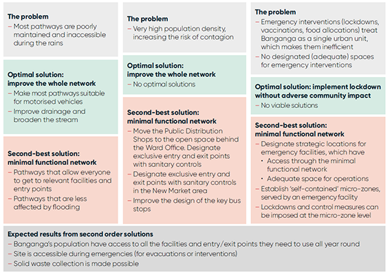
Transcript of the information contained in the table above (figure 1):
Column 1
The problemMost pathways are poorly maintained and inaccessible during the rains |
Optimal solution: improve the whole network
|
Second best solution: minimal functional network
|
Column 2
The problemVery high population density, increasing the risk of contagion |
Optimal solution: improve the whole networkNo optimal solutions |
Second best solution: minimal functional network
|
Column 3
The problem
|
Optimal solution: implement lockdown without adverse community impact
|
Second best solution: minimal functional network
|
Final row
Expected results from second order solutions
- Banganga’s population have access to all the facilities and entry / entrance points they need to use all year round
- Site is accessible during emergencies (for evacuations and interventions)
- Solid waste collection is made possible
Policy recommendations
- Recognise that primary challenges to sustain community participation in spatial planning and territorial interventions arise due to a lack of administrative will, belief in community participation, and key capacities within local authorities to effectively utilise shareware tools, and an institutional inability to appreciate the value of and implement SOS.
- Community engagement needs to be an iterative and ongoing process – from definition of problems, design of community-level data collection strategies and discussion, validation, and redesign of proposed solutions. Community engagement should complete a full cycle of planning, monitoring, evaluation, and revising plans based on findings.
- Ownership and active participation of local authorities is key to define the focus of CEDSS, to gain access to existing city-level data and ensure that there is buy-in to the identified SOS. Working across city departments is also necessary for success.
- Geospatial maps and similar visual tools provide an efficient mechanism to gain a broader perspective on the spatial nature of the community’s problems and to identify SOS, as well as to build trust between authorities and communities. To encourage participation, CEDSS tools must be based on off-the-shelf freeware and a straightforward field and analytical protocols. Much depends on the behaviour and attitudes of facilitators and who controls the process. Technical and social experts must work together to achieve integration of community data and for identification of community-led solutions.
- The solutions identified with communities should be converted into implementable plans whose delivery is undertaken in a reasonable time period to sustain the communities’ trust and motivation to take ownership of new solutions.
- SOS are a practical means to incrementally enhance the quality of life of urban residents in the short term, whilst strengthening trust and legitimacy between otherwise marginalised or excluded groups and their local authorities. SOS should therefore be viewed as sustaining the relationships required for complex and longer-term systemic urban transformation.
Notes
1 Although it is more time-consuming to build physical models, the relational nature of spatial features can be more recognisable in a model than in a map and people tend to engage more.
Further reading
Chambers, R. (2006) ‘Participatory Mapping and Geographic Information Systems: Whose Map? Who is Empowered and Who Disempowered? Who Gains and Who Loses?’, Electronic Journal of Information Systems in Developing Countries 25.1: 1–11
UN-Habitat (2021) Informal Settlements and Covid-19, Nairobi: United Nations Human Settlements Programme
QGIS Association (2021) QGIS User Guide: QGIS 3.16
Open Data Kit (2021) Guide to Mobile Survey Data Collection
Ministry of Housing and Urban Affairs (2019) DataSmart Cities: Empowering Cities Through Data, Government of India
Credits
This IDS Policy Briefing was written by Jaideep Gupte (Principal Investigator, [email protected]), Louise Clark (IDS); Debjani Ghosh, Sarath Babu, Priyanka Mehra, Asif Raza, Vaibhav Sharma (NIUA); Yogesh Kumar, Alpana Mishra, Kabir Shrivastava, Pranjal Kulkarni (Samarthan); Ricardo Fort, Alvaro Espinoza, Adrian Chuquipiondo (GRADE); and Jeetendra Rathore, Divya Pillai (Bhopal Smart City).
It was produced as part of the Capacity Building for Smart Data and Inclusive Cities (SDIC) project with the financial support of the European Union. Its contents are the sole responsibility of IDS, NIUA, Samarthan, GRADE, and Bhopal Smart City, and do not necessarily reflect the views of the European Union or IDS.
© Institute of Development Studies 2022. All rights reserved. Licensed to the European Union under conditions.